


Henefer Voting District, Summit County, Utah
About
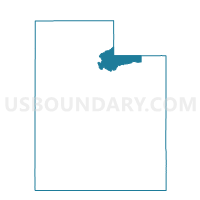
Outline

Summary
| Unique Area Identifier | 679961 |
| Name | Henefer Voting District |
| County | Summit County |
| State | Utah |
| Area (square miles) | 57.27 |
| Land Area (square miles) | 57.27 |
| Water Area (square miles) | 0.00 |
| % of Land Area | 100.00 |
| % of Water Area | 0.00 |
| Latitude of the Internal Point | 41.00204230 |
| Longtitude of the Internal Point | -111.49881220 |
Maps


Graphs
Select a template below for downloading or customizing gragh for Henefer Voting District, Summit County, Utah


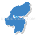

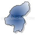

Neighbors
Neighoring Voting District (by Name) Neighboring Voting District on the Map
- Canyon Creek 4A, Morgan County, UT
- Canyon Creek 4B, Morgan County, UT
- Coalville North Voting District, Summit County, UT
- Croydon, Morgan County, UT
- Echo Voting District, Summit County, UT
- South Morgan 5B, Morgan County, UT
Top 10 Neighboring County Subdivision (by Population) Neighboring County Subdivision on the Map
- Morgan North CCD, Morgan County, UT (8,042)
- Coalville CCD, Summit County, UT (4,865)
- Morgan South CCD, Morgan County, UT (1,427)
Top 10 Neighboring Place (by Population) Neighboring Place on the Map
Top 10 Neighboring Unified School District (by Population) Neighboring Unified School District on the Map
Top 10 Neighboring State Legislative District Lower Chamber (by Population) Neighboring State Legislative District Lower Chamber on the Map
Top 10 Neighboring State Legislative District Upper Chamber (by Population) Neighboring State Legislative District Upper Chamber on the Map
Top 10 Neighboring 111th Congressional District (by Population) Neighboring 111th Congressional District on the Map
Top 10 Neighboring Census Tract (by Population) Neighboring Census Tract on the Map
- Census Tract 9701, Morgan County, UT (8,042)
- Census Tract 9641.02, Summit County, UT (2,813)
- Census Tract 9641.01, Summit County, UT (2,052)
- Census Tract 9702, Morgan County, UT (1,427)